The year 2026 has started with such a bang that there is turmoil in the whole world. Now America was in the news due to changes in its foreign policy and the growing intentions of President Donald Trump. Now superpower America is making headlines because of an unprecedented winter storm, which is being called ‘Winter Storm Fern’. This storm is the most serious in the last few years. This storm starts from the Southern Rockies and extends to the Midwest, Mid-Atlantic and Northeast. The way America has been wrapped in a white blanket of cold is very scary.
According to the National Weather Service, this storm is affecting an area of more than 2,000 miles, which includes heavy snowfall, freezing rain (freezing rain), sleet (a mixture of snow and rain) and extremely cold winds, due to which the temperature has reached below minus 40 in some places. At least 22 states of America have declared emergency and more than 200 million people are affected. This storm started from January 23 and is expected to remain at its peak till January 26, although the cold wave will continue even after this.
Why is the storm considered dangerous?
This is considered to be the worst in the last several years and according to some reports in about 40 years because of the snowfall as well as catastrophic ice accumulation. Let us tell you that ice accumulation is a thick layer of ice, which can cause power outages and affect travel for a long time.
What is the real reason for the arrival of this storm?
This storm is the result of complex weather processes, which are linked to climate patterns and short-term weather dynamics. The main reason for this is believed to be disruption of the polar vortex. The polar vortex is a circle of cold air that rotates around the North Pole. Due to a stratospheric warming event in January 2026, this vortex weakened and stretched, causing cold Arctic air to flow southward. This brought many arctic blasts, i.e. extremely cold winds, which brought the temperature below normal by 35-45°F. This pattern started forming from December 2025 itself, but reached its peak in January.
Is climate change also the cause of storms?
Some experts believe that this may be related to climate change, as global warming makes the polar vortex more unstable, but this is mainly the result of natural variability (El Niño/La Niña pattern). The storm originated in the Southwest, where subtropical moisture (warm, moist air from the Gulf of Mexico) rose over cold Arctic air. This creates an overrunning setup, where moisture in the upper air falls as snow or rain. A strong jet stream and low-pressure system further intensified it.
What is the role of weather models in storms?
Weather models also include factors related to the storm. The GFS and European models showed that cold air damming and freezing of mountain winds increased ice formation. This pattern was forming since mid-January and came in several waves. In such a situation, this storm seems to be a super arctic blast caused by them. Overall, this is a rare combination where cold, moisture and jet stream came together, which is similar to the historic cold storm of 1985.
What is the situation like in America after the storm?
The effects of the storm are extremely serious. It can be seen by dividing it into different categories.
Travel and Transportation: According to different reports, more than 10000-13000 flights have been canceled here. Snow and ice on roads have made travel impossible, especially in the South and Mid-Atlantic. The NWS has warned of catastrophic impact, including prolonged road closures and accidents.
Power failure: More than 135,000 homes and businesses are without power, primarily due to ice downing trees and power lines. It is more in the South, where ice has accumulated up to 0.25-1 inch. Outages may last for several days because the cold makes repairs difficult.
Weather conditions: Heavy snowfall (6-18 inches or more) has created whiteout conditions. The roads have become smooth and slippery due to ice. Wind chills reaching -20°F to -50°F. After that the cold wave may continue till February.
Economic and Social Impact: Schools are closed and businesses are being affected. Grocery, heating and insurance costs have increased. The total loss could be in millions of dollars. Apart from this, till now there are reports of 4 deaths due to weather, the number may increase.
Heavy rain and severe storms in the South (from Louisiana to Florida) have increased the risk of infrastructure damage, such as tree falls and flooding.
Understand the science behind snow storms
This entire system starts from the North Polar region. The very cold and heavy air accumulated there is moving towards the south. Usually this air remains upwards, but this time due to atmospheric conditions it is spreading downwards to a large part of America. At the same time, hot and moisture-laden air from the southern parts of America and the Gulf of Mexico is moving north. When these two completely different types of winds, one extremely cold and the other hot and humid, collide with each other, the weather becomes unstable. This collision produces snowfall, hail and freezing rain.

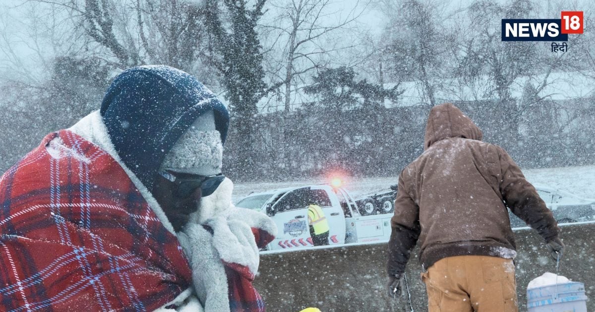
America Winter Storm: Normal life has been affected due to heavy snowfall. People are busy collecting essential goods. (File photo/Reuters)
An important reason that gives strength to this storm is the low-pressure system, which is moving from west to east. This system pulls moisture from the south and raises it up. On the other hand, a high-pressure system is present near the south-eastern coast of America, which can push the hot air further north. The biggest question for meteorologists is whether the cold Arctic air and this low-pressure system will phase completely, that is, together create a more powerful storm. If this happens, the snowfall area may shift further north and the situation may become worse in many states.
Forecasting winter storm is difficult
Winter storms are considered the most difficult to predict. this is due to –
- A difference of just 1–2 degrees in temperature can decide whether it will rain or snow.
- A slight change in wind direction in the upper atmosphere can change the path of a storm.
- Snow and rain often fall in bands, meaning heavy snow in some areas and very little in nearby areas.
- That is why weather models are updated frequently and projections keep changing.
What to understand overall?
This storm is not created by any one reason, but by the coming together of many meteorological forces. Cold Arctic air, moisture coming from the south, low-pressure and high pressure systems, and movement in the upper atmosphere, all together have made the situation serious. This is why scientists are warning that this storm may become disorganized and disorganized. Somewhere heavy snow, somewhere thick layer of snow and somewhere just extremely cold, wet weather. Its effect can also be prolonged.